The Ultimate Real Estate Professional’s Guide to Preparing Properties for High-Impact Drone Photography

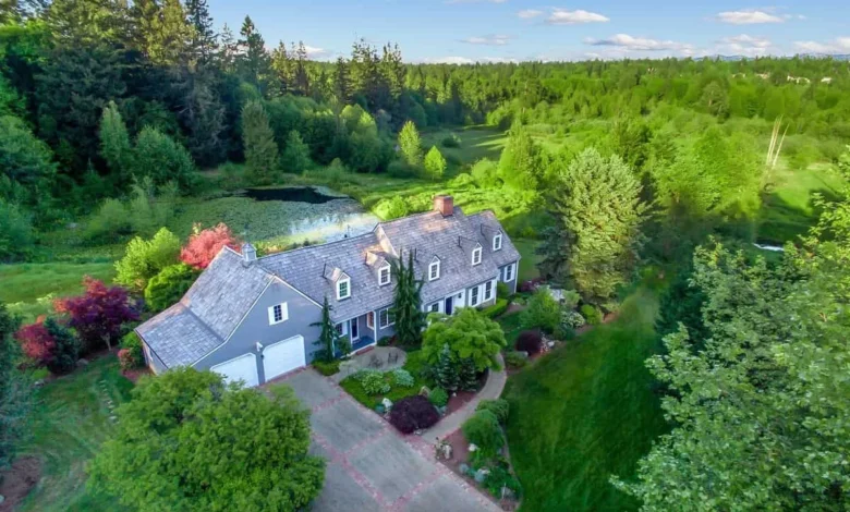
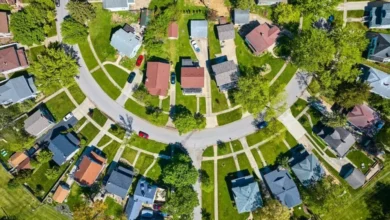
The modern real estate market has experienced a fundamental shift in how residential and commercial properties are marketed, driven largely by the proliferation of high-resolution aerial imaging. As drone technology transitions from a novelty to a standard industry tool, real estate brokerages, architectural firms, and independent sellers face new demands in property preparation. Unlike traditional ground-level photography—which captures a home through the perspective of a pedestrian standing at the front curb or walking through an entryway—aerial drone photography alters the spatial hierarchy of a listing. From an altitude of 150 to 200 feet, architectural features, topographical layouts, and boundary lines are exposed in ways that traditional marketing materials routinely miss. Consequently, proper pre-flight preparation has evolved into an essential component of the contemporary home-selling playbook.
Market Context and the Evolution of Aerial Real Estate Marketing
Over the past decade, the integration of Unmanned Aircraft Systems (UAS) into residential real estate has revolutionized how buyers evaluate properties prior to scheduling in-person viewings. Industry analyses from prominent real estate brokerages indicate that listings featuring aerial photography and videography experience significantly higher digital engagement rates compared to those relying solely on interior and ground-level exterior shots. This surge in consumer demand is rooted in the buyer’s desire for spatial context. While a standard wide-angle lens can capture a living room or a backyard patio, it struggles to convey the relationship between a property and its surrounding neighborhood, local green spaces, proximity to waterways, and overall lot dimensions.
However, this heightened visibility introduces unique challenges for sellers and listing agents. From an overhead perspective, minor spatial oversights transform into prominent visual obstructions. A blue recycling bin tucked beside a garage, a garden hose looped near a patio, a stray pool float, or accumulated leaf debris on a rooftop can quickly detract from a home’s architectural appeal. According to industry experts, the primary objective of a drone shoot is not to artificially manufacture a sterile environment that strips a home of its character, but rather to eliminate visual noise. By removing transient clutter, sellers allow potential buyers to assess the property’s true value, structural integrity, and functional layout.
Chronology of a Successful Drone Shoot: From Inspection to Liftoff
Preparing a property for an aerial photography session requires a structured, chronological approach that begins days before the certified drone operator arrives on-site. Real estate professionals recommend treating a drone shoot with the same level of logistical rigor as a mandatory structural home inspection or a formal appraisal.
Phase one begins three to five days prior to the scheduled flight. During this window, homeowners and agents must evaluate the property’s macro-elements, starting with the roof. Industry veterans emphasize that from 150 feet in the air, the roof constitutes the single largest surface area captured within the frame. Haye Kesteloo, founder and editor-in-chief of DroneXL, notes that homeowners must address roof maintenance with the same diligence applied to front lawns. This includes clearing accumulated pine needles, cleaning gutters, and addressing visible moss streaks or damaged shingles well in advance of the photographer’s arrival. Furthermore, if a roof requires cleaning, property owners are advised to employ gentle washing techniques suited to specific roofing materials—such as avoiding high-pressure washers on asphalt shingles—to prevent structural damage while enhancing visual presentation.
Phase two focuses on the 24 hours leading up to the shoot. Logistics during this period dictate the operational success of the flight. Vehicles must be permanently relocated from the driveway and adjacent street parking zones to ensure unobstructed sightlines and to provide the certified pilot with a safe, designated launch and landing zone. Automated lawn irrigation systems should be temporarily disabled; damp pavement photographs as irregular dark blotches and uneven wet patches from above, undermining the clean lines of concrete driveways and stone pathways.
Top-Down Perspectives: Mastering the Overhead View
The most common mistake property sellers make is staging exclusively for eye-level viewing. While sweeping front steps and arranging patio cushions are standard practices for traditional interior-exterior packages, aerial photography introduces a top-down perspective that looks directly into side yards, back patios, and upper-level decks simultaneously.
Justin Phillips of American Guerilla Marketing underscores the unforgiving nature of this perspective. Because aerial cameras capture the entire parcel at once, localized messes that easily escape notice from ground level become glaring focal points from overhead. Common oversight items include stray garden tools, stacked firewood, uncovered trash receptacles, children’s toys, and decaying organic debris wedged between hardscaping elements.
To mitigate these issues, property owners are advised to conduct a comprehensive perimeter walk, adopting the viewpoint of a hovering camera rather than a passing pedestrian. The objective is to establish clean lines and defined zones of utility. Outdoor dining sets should be neatly centered, lounge chairs aligned symmetrically, and grills thoroughly cleaned. The outdoor space must communicate a clear, functional purpose—whether it is a designated dining area, a relaxing poolside deck, or an open lawn suited for recreational activities—without appearing overly clinical or stage-managed.
Regulatory Compliance and Pilot Coordination
Beyond aesthetic preparation, coordinating a real estate drone shoot involves navigating strict federal regulations and operational protocols. Commercial drone operations in the United States are governed by the Federal Aviation Administration (FAA) under Title 14 Code of Federal Regulations Part 107. These regulations require commercial drone pilots to hold a valid Remote Pilot Certificate, adhere to airspace authorization protocols, and comply with local restrictions regarding altitude, weather minimums, and proximity to populated areas or controlled airspace.
Industry professionals stress that property owners should never attempt to manage airspace coordination or contact local aviation authorities independently. Certified Part 107 pilots are professionally equipped to handle pre-flight airspace checks, LAANC (Low Altitude Authorization and Notification Capability) clearances, and safety assessments. Jeffrey R. Theisler of Imaging in the Sky advises sellers to delegate aviation logistics entirely to the professional operator while channeling their own efforts into exterior preparation.
"Sellers don’t need to call the airport—a Part 107-certified pilot handles airspace authorization, so skip that and focus on what the camera actually sees," Theisler explains. He also emphasizes the critical role of environmental lighting in aerial photography, recommending that shoots be scheduled during the optimal window leading up to sunset, while allowing the experienced pilot ultimate discretion over the flight date to avoid unfavorable flat, overcast lighting conditions.
Broader Economic Implications and Market Impact
The growing reliance on high-end aerial media reflects broader economic shifts within the real estate sector. As digital listing platforms become the primary gateway for prospective homebuyers, the quality of visual media directly correlates with market velocity and final sale prices. Properties that successfully leverage drone photography often generate higher initial digital traffic, leading to increased foot traffic during open houses and, in many competitive markets, reduced cumulative days on market (DOM).
However, real estate analysts caution against using aerial photography to obscure material defects or structural compromises. While clearing away debris, fallen branches, and unmaintained equipment enhances aesthetic presentation, it does not substitute for legally mandated disclosures or necessary property repairs. Discerning buyers routinely commission independent home inspections, and transparency remains a cornerstone of ethical real estate transactions. Drone media should serve to highlight the inherent architectural strengths, landscaping assets, and spatial advantages of a property rather than masking deferred maintenance.
Summary Checklist for Pre-Shoot Preparation
To ensure optimal results during an aerial real estate photography session, sellers and agents should execute a systematic walkthrough using the following verified industry guidelines:
- Roof and Gutters: Clear all accumulated leaves, pine needles, and organic debris from the roof surface and rain gutters. Address moss or algae streaks using material-appropriate cleaning methods.
- Vehicles and Hardscaping: Remove all automobiles from the driveway and street parking spaces directly in front of the property. Sweep walkways, patios, and driveways to eliminate loose dirt and gravel.
- Waste Management: Securely store all trash, recycling, and yard-waste bins inside the garage or behind privacy fencing out of overhead view.
- Landscaping and Vegetation: Trim overgrown tree branches that obscure the roofline, architectural features, patios, or pools. Ensure fresh cuts are minimized and debris is completely hauled away.
- Outdoor Staging: Straighten patio furniture, center dining tables, align lounge chairs around pool decks, and remove visible garden hoses, stray toys, and unorganized storage containers.
- Irrigation Control: Turn off automated lawn sprinklers at least 12 hours prior to the scheduled shoot to prevent dark, uneven wet spots on driveways and paved surfaces.
- Pilot Coordination: Confirm the operator holds active FAA Part 107 certification and liability insurance, and collaborate on selecting an optimal weather window to maximize natural lighting conditions.
By combining meticulous exterior preparation with professional aerial piloting, sellers can effectively showcase the true spatial dimension and market value of their property, ensuring their real estate listing stands out in an increasingly competitive digital marketplace.