
Weather models are painting a stark picture of the coming months, with a burgeoning El Niño climate phase showing the potential to become one of the most powerful ever recorded. This phenomenon, often colloquially referred to as a "super El Niño" or even a "Godzilla El Niño," carries the ominous promise of widespread climatic disruption, from severe droughts in some regions to catastrophic flooding in others, and is poised to set the stage for potentially the hottest year on record.
"The forecast from now is warming faster in the tropical Pacific than at any other time so far this century," stated Adam Scaife, head of long-range forecasting at the Met Office, the UK’s national weather service. "So something unusual is going on." This accelerated warming trend in a critical oceanic region is a key indicator that current climate patterns are deviating from the norm, signaling the potential for significant global repercussions.
Understanding the El Niño Phenomenon
El Niño is a naturally occurring climate pattern characterized by the warming of sea surface temperatures in the central and eastern tropical Pacific Ocean. This warming is driven by a weakening of the east-to-west trade winds, which normally push warm surface water towards the western Pacific. When these winds subside, the accumulated warm water sloshes back eastward, disrupting oceanic circulation and atmospheric patterns worldwide.
The threshold for an El Niño event is typically defined as sea surface temperatures in the central Pacific rising 0.5°C (0.9°F) above the long-term average. A "super El Niño," however, signifies a much more intense event, with temperatures reaching 2°C (3.6°F) or more above the average. Historically, these super events are rare, with documented occurrences in 1982-83, 1997-98, and 2015-16. The name "El Niño," meaning "the Christ child" in Spanish, was given by Peruvian fishermen who observed this warming phenomenon around Christmas time.
The Likelihood and Projection of a Super El Niño
Recent atmospheric activity has significantly increased the probability of a powerful El Niño event. A notable burst of westerly winds in March and early April has propelled vast quantities of warm water towards the central and eastern Pacific, a precursor to intensified El Niño conditions. Met Office models are projecting that the temperature anomaly in this crucial region could approach 2°C by September.
Adding to these concerns, a suite of models run by the European Centre for Medium-Range Weather Forecasts (ECMWF) indicates a roughly 50% chance of the temperature anomaly reaching 2.5°C by October. The US National Weather Service has placed the probability of a super El Niño at 25% by the end of the year. Furthermore, if two specific models within the ECMWF ensemble, which are projecting central Pacific temperature anomalies exceeding 3°C by September, prove accurate, this event could surpass all previously recorded El Niños in strength.
However, meteorologists caution that the signs are still relatively faint at this early stage. Predicting the precise strength of an El Niño is notoriously challenging due to what is known as the "spring predictability barrier." This phenomenon occurs because the atmospheric and oceanic conditions in the spring are often in transition, making it difficult for models to accurately forecast the subsequent development. A clearer picture of the potential magnitude of the coming El Niño is expected to emerge in May or June.
Global Weather Ramifications and Historical Parallels
The alterations in atmospheric circulation triggered by El Niño in the Pacific Ocean have far-reaching consequences, propagating across the globe through complex atmospheric pathways known as "teleconnections." These teleconnections can lead to a cascade of impacts, including crop failures, coral bleaching events, and increased prevalence of certain diseases, collectively causing billions of dollars in economic damages annually.
"Things are perturbed, they’re shifted away from normal," explained Tim Stockdale, a senior research scientist at the ECMWF. "It’s not necessarily that the storms, let’s say rainfall, is more… It’s just happening in places that don’t normally get it."
Historically, El Niño events typically bring increased stormy and wet weather to the southern coasts of North and South America, the Horn of Africa, and China, heightening the risk of widespread flooding. Conversely, regions such as Australia, Southeast Asia, central and southern Africa, India, and the Amazon rainforest often experience hot, dry conditions, leading to increased risks of drought, heatwaves, and devastating wildfires.
The United Kingdom and northwestern Europe’s climate response to El Niño is more nuanced. While it can increase the likelihood of hotter summers and colder winters, it can also contribute to wet, mild winters, depending on the interplay with other concurrent climate patterns.
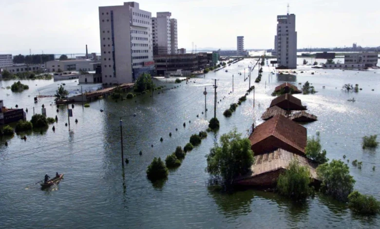
The most devastating impacts of an El Niño event can persist long after its peak. A stark reminder of this was the 1997-98 super El Niño. In the summer following its peak, China’s densely populated Yangtze River valley experienced severe rainfall and catastrophic flooding. This disaster resulted in an estimated 3,000 fatalities, displaced 15 million people from their homes, and caused approximately $20 billion in economic losses.
On a more positive note for some regions, El Niño tends to suppress hurricane formation in the Caribbean and off the east coast of the United States. The amplified atmospheric circulation associated with El Niño leads to greater wind shear, a phenomenon that can quickly dissipate developing tropical storms before they can evolve into major hurricanes.
The Amplifying Effect on Global Temperatures
The influence of El Niño on global temperatures can be viewed as a significant, albeit temporary, surge atop the ongoing trend of global warming. Climate change is akin to a gradually rising tide, steadily increasing global temperatures. El Niño acts as a powerful wave that temporarily elevates these temperatures even further. A strong El Niño event can boost global average temperatures by approximately 0.2°C.
The most recent El Niño event, which concluded in 2024, was a significant factor in the record-breaking global temperatures observed that year. During this period, global temperatures briefly surpassed the Paris Agreement’s critical threshold of 1.5°C above pre-industrial levels for the first time. If the anticipated super El Niño materializes, many climate scientists believe that 2027 could set a new global temperature record.
"Given that we’re already… close to 1.4, it’s quite likely or plausible that 2027 is going to go above the 1.5 threshold," noted Scaife. "It’s a sign that [global warming is] getting very close to the Paris threshold." This underscores the critical juncture the planet is approaching in its battle against rising global temperatures.
The Future of Super El Niño Events
The question of whether climate change will lead to an increase in the frequency or intensity of super El Niño events is complex. While El Niño’s warming in the central Pacific is increasing due to overall global warming, the baseline average temperature against which these anomalies are measured is also rising. This means that by the current definition, an increase in the number or strength of El Niño temperature anomalies might not be observed.
Recognizing this nuance, the US National Weather Service has begun to classify El Niño events based on how much warmer the central Pacific is compared to other tropical regions at present. This alternative definition, however, has yet to gain widespread adoption by the international scientific community.
Studies have indicated that instances of El Niño and its cooler counterpart, La Niña, have become more frequent and extreme over the past five to six decades. One study suggested that climate change has amplified these swings between warm and cool phases in the central Pacific by approximately 10%. However, given the limited length of reliable historical climate data – approximately 150 years, with early measurements being less precise – most scientists remain cautious about definitively stating that climate change is directly "supercharging" El Niño events.
"It’s a very tricky question, will El Niño change under climate change," admitted Stockdale. "The answer is it probably will."
What is unequivocally clear, however, is that global warming is exacerbating the impacts of El Niño events. Higher global temperatures lead to increased evaporation from land surfaces and greater moisture-holding capacity in the atmosphere. This amplified hydrological cycle intensifies extreme weather phenomena, such as prolonged droughts and more severe flooding.
"We call it an intensification of the hydrological cycle," Stockdale concluded. "Because El Niño can cause significant changes in normal precipitation it can be exacerbated by climate change." As the planet continues to warm, the destructive potential of El Niño events, combined with existing climate change stressors, poses an escalating threat to global ecosystems and human societies.


